Nike Site SL-10 - Marine, IL
Gallery 1
- Photo Sources:
-
- Gnnn:
- Google Maps 2015
- Rnnn:
- Ron Plante 2015
- Wnnn:
- Dave Novak 1968
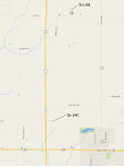
Map
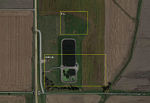
Contains a sewage treatment facility for the
village of Marine. No trace of the original Nike site remains.
- G102: Satellite image showing current sewage treatment plant.
- R026: View into admin area from approximate location of original main gate.
- R027: View of the IFC area (mound behind and to right of dirt piles).
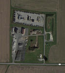
In use for storage of highway maintenance supplies and equipment by Madison County. All
original Nike site buildings have been demolished.
- G103, G104: Satellite image showing launch site in 2015.
-
R028: Main gate at the southeast corner of the site (2015).
- The ready building was just inside the gate to the left of the road.
-
Along the road in the distance were:
- Missile assembly building.
- Warheading building (berm is still visible).
- Dog kennel.
- Entrance to launch area.
- R029: Launch area is barely visible in the background just to the right of center (2015).
- R030: New gate installed by Madison County at the southwest corner of the site.


